
Elevated Arsenic Detected in Wells at Reclaimed Flambeau Mine Site
*Editor’s Note: there has never been a sulfide mine that has not polluted.
For Immediate Release, March 1, 2024
Contacts: Laura Gauger, Deer Tail Scientific (Duluth, MN); Tel: (218) 724-3004
Dr. David M. Chambers, Center for Science in Public Participation (Bozeman, MT); Tel: (406) 585-9854
Elevated Arsenic Detected in Wells at Reclaimed Flambeau Mine Site
– Wells within 140 feet of Flambeau River are Contaminated; State officials have taken no action
Groundwater quality testing at the reclaimed Flambeau Mine site south of Ladysmith has revealed high concentrations of arsenic in two wells located within 140 feet of the Flambeau River. Wisconsin’s drinking water standard for arsenic is 10 parts per billion (ppb). Water samples collected from the wells in May 2023 and tested by Flambeau Mining Company (FMC) and the Wisconsin Department of Natural Resources (DNR) show arsenic concentrations ranging from 15 to 24 ppb.
Before the Flambeau Mine was constructed in the early 1990s, arsenic concentrations of less than 5 ppb were reported in wells across the project site (i.e., the toxin was undetectable). That changed in 1999, shortly after the mine’s waste water treatment plant (WWTP) was shut down and the unlined mine pit was backfilled with the sulfide-containing waste rock and WWTP sludge that had been generated during operations and stored on liners alongside the mine pit.
Arsenic concentrations ranging from 42 to 83 ppb were measured in the deepest wells within the backfilled Flambeau Mine pit in July 1999 and remain elevated to the present day (41 to 53 ppb in May 2023). Arsenic concentrations in the two wells mentioned at the outset, both located in a 140-foot-wide sliver of bedrock between the backfilled pit and Flambeau River, spiked in 1999 as well and have exceeded Wisconsin’s 10 ppb drinking water standard on numerous occasions over the past two decades.
Other contaminants have also exceeded standards in a number of wells at the project site. Manganese, which is known to cause Parkinson’s-like nerve damage at elevated concentrations, has gone as high as 42,000 ppb in a well within the backfilled Flambeau Mine pit, compared to the public health standard of 300 ppb.
According to information provided by FMC to the Wisconsin DNR, the contaminated water from the backfilled Flambeau Mine pit is on the move and entering the Flambeau River. As stated in the company’s 1989 Mine Permit Application:
“ … all of the groundwater flowing through the [high sulfur] waste rock in the reclaimed pit will exit the pit through the Precambrian rock in the river pillar and flow directly into the bed of the Flambeau River. Since this flow path is very short and occurs entirely within fractured crystalline rock, … the concentrations of [dissolved] constituents in the groundwater leaving the pit will be the same as the concentrations entering the river bed.”
Longtime conservationist Laura Gauger claims that FMC and its parent company, Kennecott/Rio Tinto, misled the public regarding the likelihood of contaminated waters entering the Flambeau River from the backfilled mine pit and has backed up the claim with a photo of a plaque that FMC displayed at the mine site during operations in the mid-1990s.
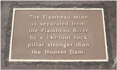
Plaque displayed by FMC at the Flambeau Mine project site in the mid-1990s.
Gauger, who co-authored a book about the Flambeau Mine with Roscoe Churchill of Ladysmith in 2007, recounted the following story:
“During the 1989-90 permitting process for the Flambeau Mine, local citizens voiced concerns that groundwater polluted with heavy metals from the Flambeau Mine would get into the nearby Flambeau River. In response, FMC distributed a brochure claiming the bedrock between the mine pit and river would provide a barrier ‘stronger than the Hoover Dam.’ The company reiterated the claim on a plaque displayed at the project site in the mid-1990s.”
She continued: “Years later, a public records request unearthed a technical report that FMC had submitted to the Wisconsin DNR in 1989 as part of the permitting process – a report that concluded the rock between the pit and river was ‘fractured’ and that contaminated groundwater leaving the mine pit would ‘flow directly into the bed of the Flambeau River.’ The public had been duped.”
In light of the high concentrations of arsenic now being recorded in wells at the Flambeau Mine project site, concern has once again been raised by citizens for the health of the Flambeau River. The DNR-approved monitoring plan for the river, however, does not require FMC to report any biological or surface water sampling data for the section of the Flambeau River immediately adjacent to the backfilled mine pit where the contaminated groundwater is entering.
The closest surface water sampling site in the Flambeau River is about 500 feet downstream of the backfilled pit, and the closet biological sampling station, last sampled by FMC in 2011, is about 2,000 feet downstream. The test panel utilized by the company for surface water analysis is also limited. The only metals being tested are copper, iron, manganese and zinc. The DNR has not required FMC to test the river water for arsenic, sulfate or a variety of other substances known to be present in Flambeau waste rock such as uranium, aluminum, cobalt and nickel.
Nor has the DNR required FMC to drill any monitoring wells on the west side of the Flambeau River (opposite side from pit) to determine if the plume of groundwater contamination emanating from the backfilled pit and headed in that direction has extended beyond the river to properties on the other side.
A 1988 memo issued by Foth, FMC’s primary environmental consultant, included the following statement that apparently was designed to rationalize the decision to drill no wells west of the river and quell public concern: “The river is in the way. It is clearly impossible, then, for any activities at the mine, on one side of the river, to affect any water wells on the other side of the river.”
Foth’s sweeping statement has been challenged by experts like Dr. Robert E. Moran (Michael-Moran Associates, Golden, CO), a seasoned hydrogeologist who reviewed FMC’s monitoring program several years ago. He pointed out that the Flambeau River “is only about 5 feet deep in the vicinity of the 225-foot deep mine pit” and stated that “the overall hydrogeological relationships … indicate significant volumes of pit groundwater may be flowing downgradient below the Flambeau River, in the deeper alluvial sediments and or bedrock.”
Dr. Moran went on to advocate for wells being drilled and tested on the west side of the river “to determine whether groundwaters west of the Flambeau River have been negatively impacted by FMC operations.” The same recommendation was made by Dr. David M. Chambers and Dr. Kendra Zamzow (Center for Science in Public Participation, Bozeman, MT) in a 2009 report that identified various surface and groundwater contamination issues at the reclaimed Flambeau Mine project site.
FMC continues to claim in annual submissions to the Wisconsin DNR that “the Flambeau River remains fully protected and Flambeau remains in full compliance with its permit standards.” But Gauger, who is concerned with FMC’s failure to test for arsenic or any other contaminants in the stretch of the river alongside the mine pit or to drill any monitoring wells west of the river, has referred to FMC’s test program as “Don’t Ask. Don’t Tell.”
In light of the high concentrations of arsenic in groundwaters exiting the backfilled Flambeau Mine pit and entering the Flambeau River, citizens are hopeful that something can be done to protect the river and properties across the river from the pit. Thus far, however, the Wisconsin DNR has taken no action.
####